

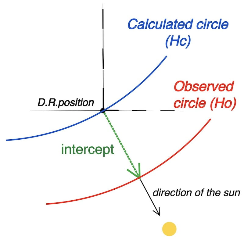
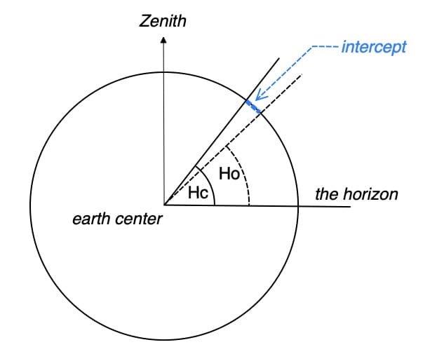
The two independent altitude circles (Ho and Hc)
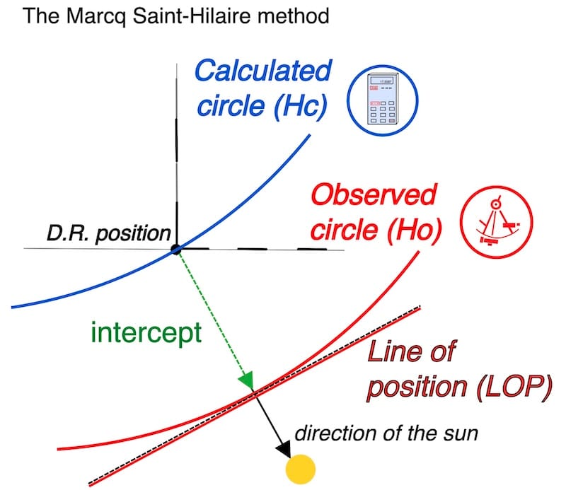
The Marcq Saint-Hilaire method compares two independent methods:
1 the sextant measurement (Ho)
2 the calculation involving the estimated position (Hc).
It uses the calculated value (Hc) as a reference to compare with the observed circle (Ho), which is represented locally as a straight line (the LOP) on a nautical chart.
THE PRINCIPLES of the celestial sun sight: Understanding the expression LOP (line of position).
Please remember that the entire context of this website originates from the La Rochelle exercise. This exercise serves as the gateway leading you to an interactive worksheet that offers comprehensive, step-by-step guidance for both calculations and theoretical aspects.

Introduction:
The St. Marcq Hilaire method involves comparing two entirely different methods:
1) Using the sextant to measure the true altitude circle, also known as the observed altitude circle (Ho).
The role of the Geographical Position (GP)
While a thread stretched between the Sun center and the Earth center strikes the Earth’s crust at the point GP.

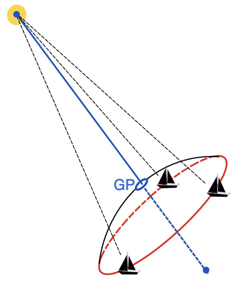

The three observers see the sun at the same angle (altitude).
The red circle is called the true or observed altitude circle after some corrections, which we will learn about on this website.
2) Calculating, from our estimated position, the appropriate altitude circle (Hc).
It is important to remember that this point (GP) is used in our mathematical spherical formulas.
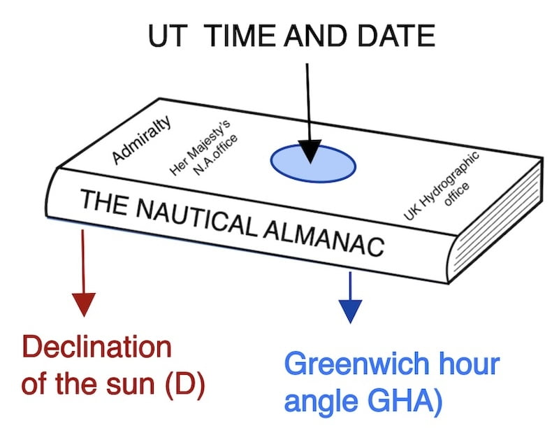
As we will see, the GP (Geographical Position) point is defined by the nautical almanac using the sun’s declination and the Greenwich Hour Angle (GHA).
So, using the GP point, our dead reckoning position, and some spherical formulas, we can calculate a circle that is almost identical to the observed true circle.
Why the estimated position matters
The required conditions are as follows: the estimated position should preferably have an uncertainty of no more than 30 miles. The time of the sextant observation must correspond exactly to the time used in the nautical almanac calculation.
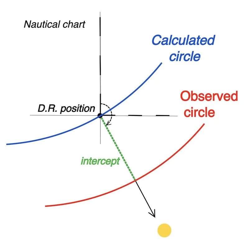
In this case, there are two independent circles: one from pure sextant measurement with minor corrections (Ho), and the other calculated from our dead reckoning position (Hc).
The relatively small distance between the two circles on the Earth is called the intercept.
From altitude circles to the Line of Position (LOP)

The estimated position serves as the reference point for plotting the true altitude (observed) circle, locally associated with a straight line, called the line of position.
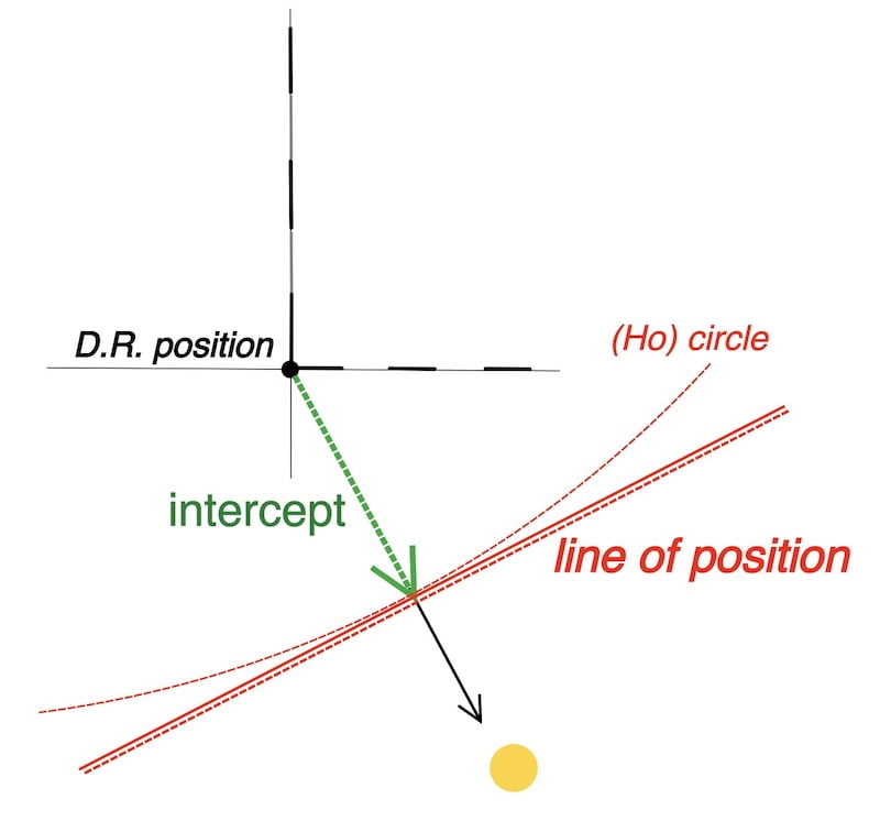
The method, which isn’t purely mathematical, involves two independent circles situated closely to each other with nearly identical characteristics; it’s also known as the intercept method.

The line of position
A Line of Position (LOP) is a marked straight line on a nautical chart that represents the potential location of a vessel, determined using a sextant and relevant calculations.

Essentially, it signifies that the vessel is positioned somewhere along this line, yet it doesn’t provide an exact fix on its location.

the solution
To accurately determine a vessel’s position, it is necessary to have the intersections of at least two LOPs. The process involves taking an initial observation with a sextant to measure the sun’s altitude above the horizon and calculate the first LOP.
Subsequently, a second observation is taken some time later as the sun changes its azimuth angle during its east-to-west movement. The second LOP is then calculated, and the intersection of these two lines reveals the vessel’s position.

THE PRINCIPLES of the celestial sun sight in 3 steps:

A Second, More Detailed Explanation of the Marcq Saint-Hilaire Method
1. Obtaining the observed circle (Ho) with the sextant.
2. Calculating the second circle (Hc) with the dead reckoning position.
3. Comparing them.

STEP 1
Obtaining the observed circle (Ho) with the sextant.


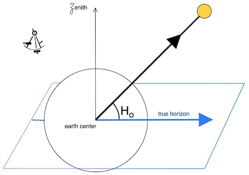
Ho (observed altitude)
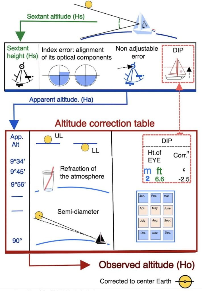
At our unknown but true position, we measure the altitude of the sun above the horizon with a sextant. This measurement is called the sextant altitude (Hs).
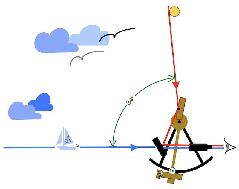
After making all necessary sextant corrections (which will be explained later), we modify this altitude as if we were at the center of the earth and call it the observed altitude.(Ho)
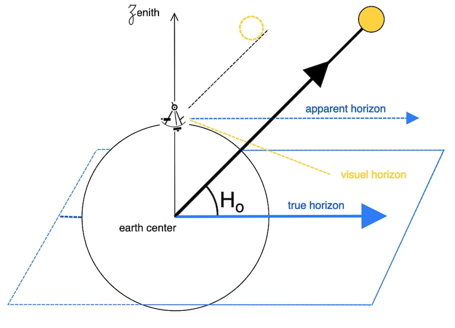
During the observation, the sextant is aimed at the Sun. The GP (Geographical Position) is the point on Earth directly beneath the Sun at that moment.
The (LOP) : line of position is a portion of the circle that is:
locally assimilated as a straight line!
The L.O.P is therefore perpendicular to the direction of the sun.

STEP 2
Calculating the second circle (Hc) with the dead reckoning position.
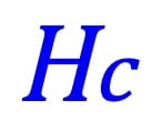

Hc (calculated altitude)
At our dead reckoning position, we use the exact time of the observation, the nautical almanac, and the spherical trigonometry formulas to calculate the altitude of the sun, which is referred to as the calculated altitude(Hc).

This means the calculations are based on positions as if observed from the Earth’s and Sun’s centers.
To summarize these spherical trigonometry formulas will always calculate from Center Earth, Center Sun, or Center Star, Moon, or Planets.
At the same time we also calculate with the spherical trigonometry formulas the direction of the sun. (azimuth)
The calculated altitude (Hc) also has its own position circle.

STEP 3
Comparing Ho and Hc

The Ho and Hc values are completely independent of each other.
Naturally, the calculated altitude includes the exact time of the observation with the sextant
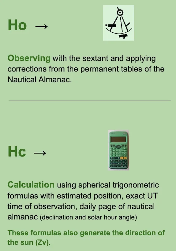
While our dead reckoning (estimated position) is not too far off from our true position, we can compare the circle of positions Ho with Hc.
To clarify we can estimate that the circle of position Ho is parallel to the circle of position Hc, since the two circles are close.
It is preferable that the dead reckoning uncertainty does not exceed 30 miles. If that is not the case, there are possibilities to refine the uncertainty distances.
In other words using dead reckoning on the map and the direction of the sun, we can draw a Line of Position Hc perpendicular to the direction of the sun that passes over our dead reckoning position.
That’s our reference!
The concept of the intercept
The distance between the two lines of positions is called the intercept and we adopt Ho – Hc = intercept.

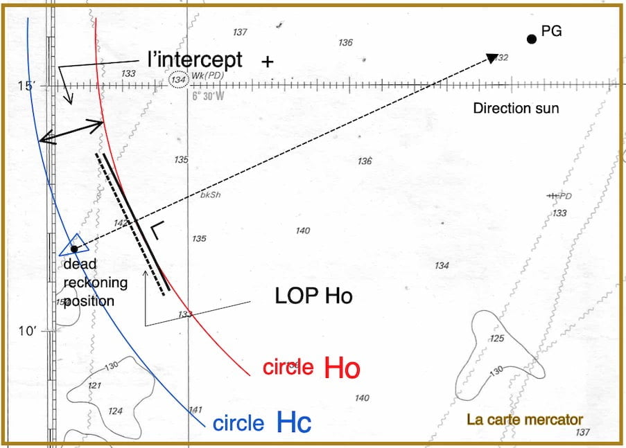

In practice, only the LOP is plotted on the chart.

Hence, imagine that your estimated position based on dead reckoning is actually your true position.
While, at this moment, you use a sextant to measure the altitude of the sun and calculate its altitude using your formulas.
In this scenario, the observed height will be equal to the calculated height.

Now, the intercept will be zero, and the two lines of positions join as they pass over the dead reckoning position perpendicular to the sun’s direction.

Firstly how to calculate the intercept?
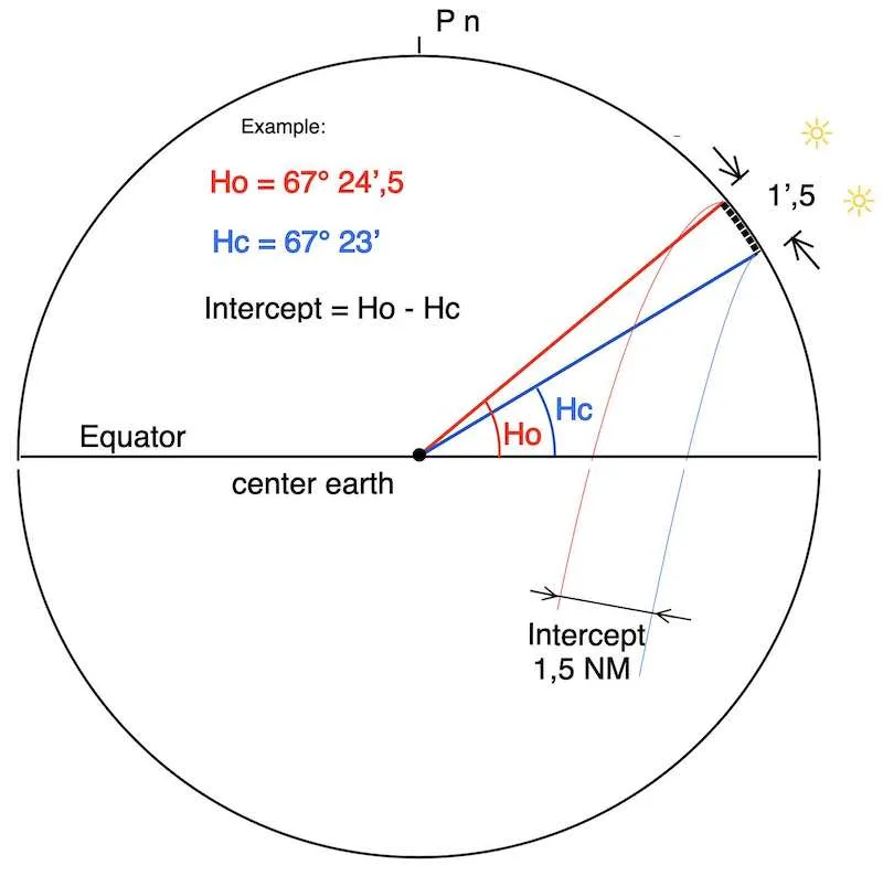
Additionally to better understand the 1′.5 nautical mile see the definition “nautical mile”
To clarify if the intercept is positive or negative:
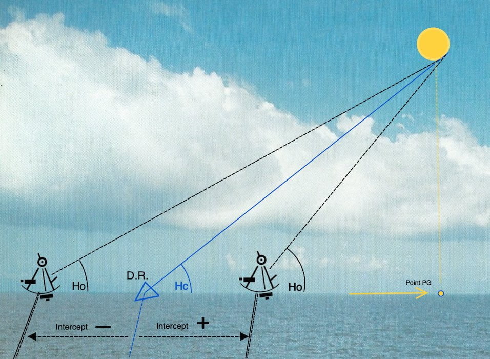
Intercept (+) Ho > Hc

+ “towards the sun”
Intercept( -) Hc > Ho
– “away from the sun”
How to draw the LOP on the map:
In conclusion four examples
+ “towards the sun” (positif)
– “away from the sun” (negatif)

In fact we will learn how to construct a map ourself.

Additional Knowledge:
Firstly, concerning the time interval between two Lines of Position (LOPs), the process of transferring a LOP, and understanding the uncertainty area associated with a LOP
Sun’s LOP running fix and the uncertainty zone.
Day planning with the two sun LOP’s
the Local Apparent Noon sight latitude,
Apart from the explanation of the Line of Position (LOP) on this page — which can be taken almost throughout the entire day — there is a special LOP called the Local Apparent Noon sight latitude, which can be taken at only one specific moment of the day.
Undoubtedly, it offers a straightforward and swift approach for determining latitude.