

Plotting sheet charts are designed for open ocean navigation. Mariners often use plotting sheets to plot Lines-of-Position (LOP) obtained through the methods of Celestial Navigation.
Therefore visual aids to navigation, shore lines and water depths are of no importance to navigation.
These plotting sheets can be used on this self-instruction website after the observation of the sun with the sextant, followed by the calculation, for drawing the Line of Position (LOP) on a nautical chart.

Make your own celestial plotting sheet:

Of course, distances are always measured from the Latitude Scale on the Chart and NOT the Longitude Scale.
See definition of a nautical mile

Make your own celestial plotting sheet: Creating a Mercator grid (plotting sheet) for a given latitude
As detailed in the image below, the longitude lines have equal distances between them, but the distances between each latitude line are increasing as the lines approach the poles.
However only at the Equator the lines of latitude and longitude are at the same distance.

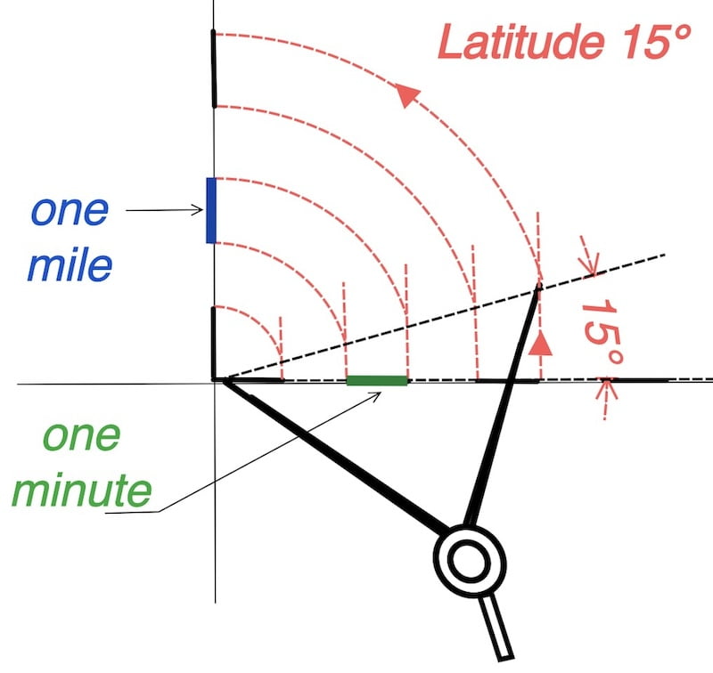
Draw the line at a 15° angle.
Choose the length of one minute on the longitude scale and draw the vertical lines.
Use a drawing compass to establish the latitude scale.

The length of the minute on the longitude scale is your choice; for example, you could take one centimeter in the metric system as the length of the minute.
Also, you can opt for the U.S. customary system, utilizing inches, half inches, or quarter inches according to your preference.
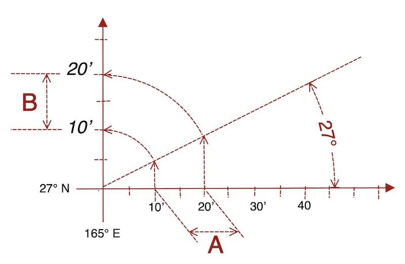
For example, for a latitude of 27°…
You can choose: A = 2 cm → B = 2.25 cm
You can choose: A = 1 inch → B = 1.12 inch
Your choice of scale depends on the intercept length, the distance between two LOPs, and the available plotting space.

Nevertheless, the length of a nautical mile depends on the latitude and the value assigned to the minute, and it increases further at higher latitudes.”
In conclusion, the measured length of a mile on a nautical chart varies between low and high latitudes, but the value of the nautical mile remains constant everywhere on Earth at 1852 meters for one mile.
Make your own celestial plotting sheet and draw a LOP
In fact, methods of Celestial Navigation obtain Lines-of-Position (LOP) for which plotting sheets are used. (see two examples below)
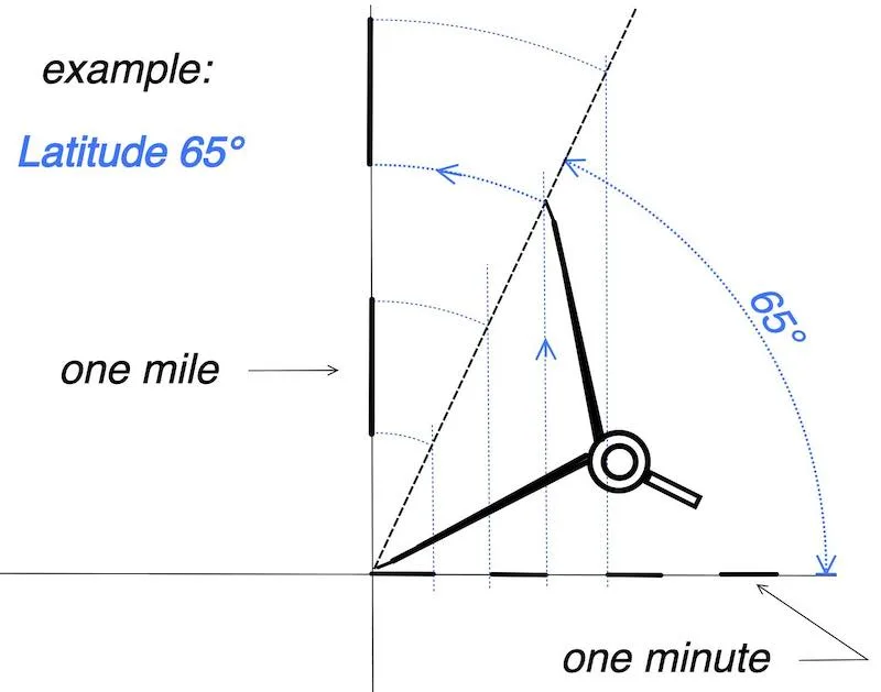
Also here is an example: With the help of our worksheet, we found the intercept to be +3′ and the azimuth to be 029°. (Latitude about 65°)
Now we draw this on our 65-degree plotting sheet.

Here is a second example: With the help of our worksheet, we found the intercept to be -6′,7 and the azimuth to be 111°. (Latitude about 15°)
Now we draw this on our 15-degree plotting sheet.

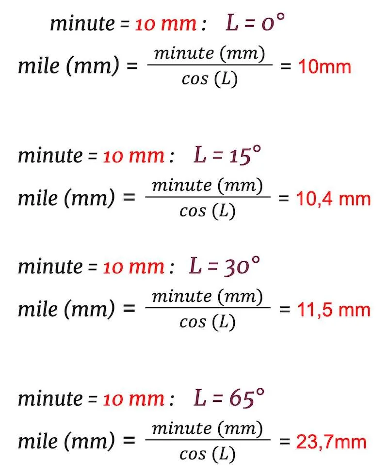
Make your own celestial plotting sheet: calculate the length of a nautical mile
One can also calculate the length of a nautical mile after choosing the length of a minute on our plotting sheet.
Remember that this minute is a fixed value chosen by the constructor.
However, latitude and the chosen value for the minute affect the value of a nautical mile, and the length of a nautical mile increases further at higher latitudes.
formula:
length minute ➗ (cos (L) 🟰 length mile
- length minute on the longitude scale
- L is the estimated latitude, rounded to the nearest degree.
- length mile on the latitude scale
U.S. customary system:

Metric system:

How does the measurement of miles on a nautical chart change with increasing latitude?
Indeed, the distortion of surfaces on a Mercator map becomes more pronounced as one moves away from the equator. At middle latitudes, the distortion is still relatively limited, but it becomes more significant at high latitudes. Generally, beyond approximately 70 degrees of latitude north or south, the distortion becomes very significant on a Mercator map and becomes unusable. At the poles, it becomes infinite.
You can also use the universal plotting sheets
