

Utilizing the local apparent noon sight latitude with the sun is a common practice in maritime navigation, providing an uncomplicated and rapid method to determine latitude.
However, this technique relies on a singular moment in the day, requiring both the sun and the horizon to be visible for accurate measurements.

This page was not originally intended because I wanted to focus on the line of position of the sun at any moment of the day, and the calculation of this line of position is far more challenging than the local apparent noon sight.
Moreover, there is also a page that explains how to calculate the local apparent noon time.

Local apparent noon sight latitude:
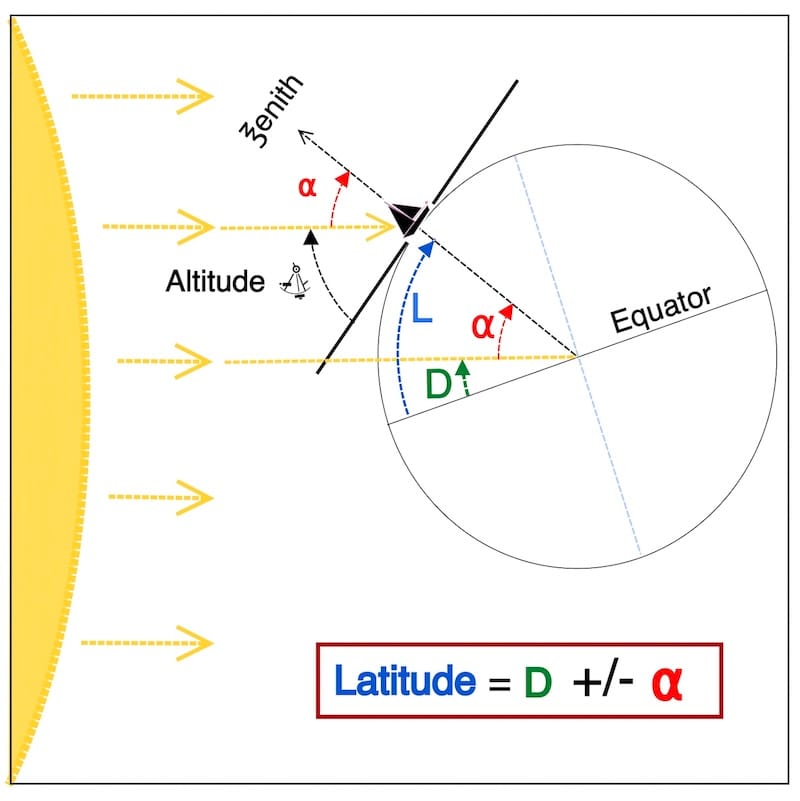
Below is the classic design illustrating the principle and formula of the local apparent noon sight
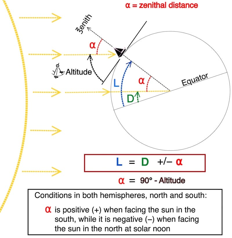
L = local apparent noon latitude
D = sun’s declination
Mnemonic used in navigation books: facing the Sun toward the south, with your back to the north, α is positive — and vice versa.
Indeed, this design is based on the fact that the sun’s rays are all parallel for an observer on Earth.
The tilt of the Earth’s axis gives us the declination (D), and together with the zenith distance ( ⍺ ), we can determine our true latitude.
Furthermore, obtain the declination (D) from the Nautical Almanac on its daily pages at the time of the local apparent noon sight.

Rainbows illuminated only by moonlight — pale, often whitish arcs seen during light rain or spray at night.
Facing the sun in the south or the north
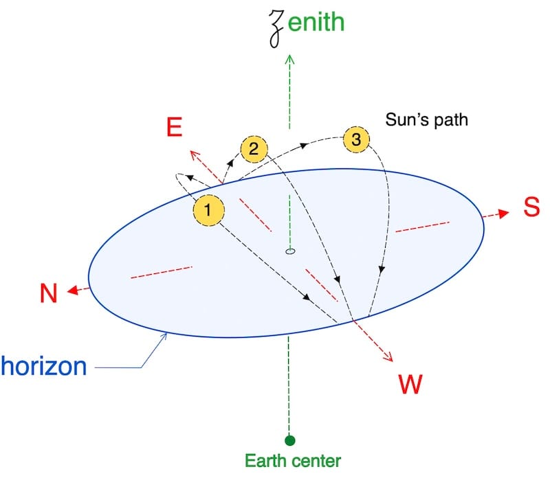
Path 2 → On this day, at solar noon the Sun is directly overhead . This situation is only possible within the tropics .
Path 3 → On this day, at solar noon the Sun is to the south of the observer.
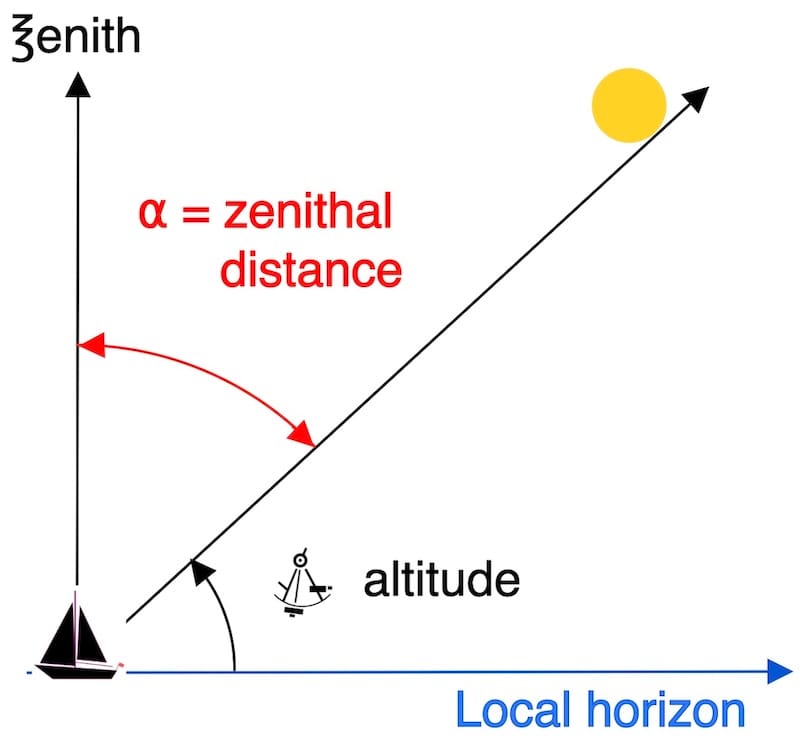
How to obtain the observed altitude (Ho)
Take the altitude of the sun with the sextant (Hs), then correct it to apparent altitude (Ha), and finally correct it to observed altitude (Ho).
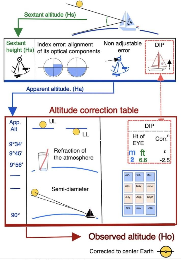
theory of the apparent altitude
how to calculate the apparent altitude
theory of the observed altitude
how to calculate the observed altitude
Local apparent noon sight latitude:

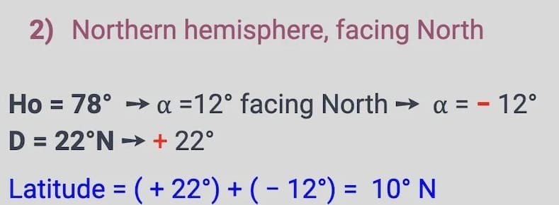
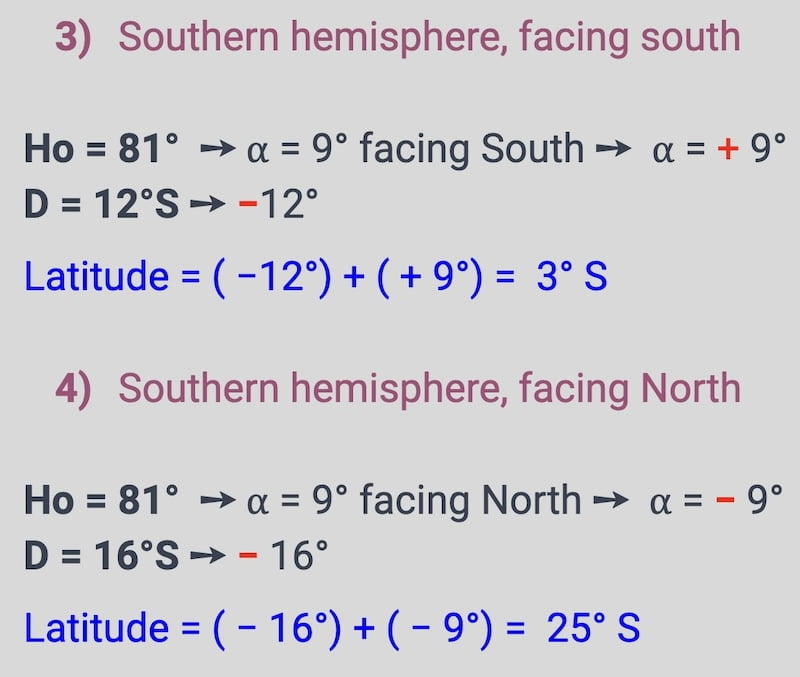
Here are four examples of how to calculate the local apparent noon latitude.
Firstly, In this exercise, we simulate as if we determined the observed altitude Ho) of the sun using a sextant at the local apparent noon time.
Also, we utilized the sun’s declination (D) for this moment obtained from the daily pages of the nautical almanac. As you already know, declination north is positive, and south is negative.
Now, calculate the local apparent noon latitude (lan) with the formula see below.
First example:
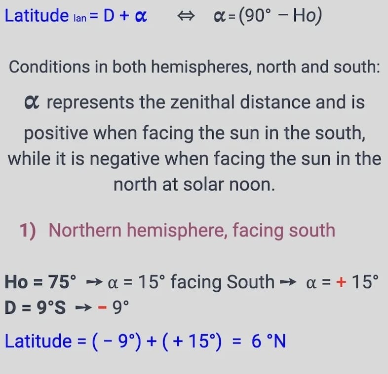
Explanation of the first example
This example shows how to determine latitude at solar noon using the Sun’s observed altitude.
The formula is:
Latitude = D + 𝜶 where 𝜶 = (90° − Ho)
- At the moment of the local Sun sight, we measured the altitude of the Sun with the sextant, called Hs.
- After applying all corrections (index error, dip, refraction, semi-diameter, parallax), we obtained the corrected altitude, called Ho.
- 𝜶 is the zenith distance. It is positive when the Sun is due south and negative when the Sun is due north, and this rule applies in both hemispheres — it is very important to remember this.
- D (declination of the Sun) is taken from the Nautical Almanac, positive north and negative south.
Step by step:
- The corrected altitude is Ho = 75°.
So, the zenith distance is 𝜶 = 90° − 75° = 15°
The Sun is due south, so 𝜶 = + 15° . - The Sun’s declination from the Nautical Almanac is D = 9° S, so D = − 9°
- Apply the formula:
Latitude = D + 𝜶 = (− 9°) + (+ 15°) = + 6° = 6° N
Thus, the ship’s position is at latitude 6° North.
After obtaining the latitude, you can simply plot it on your plotting sheet.
how to practice the apparent noon sight latitude
Practicing the apparent noon sight involves determining the time of apparent noon, which is when the sun reaches its highest point in the sky for a given location.

Take Measurements:
About ten minutes before apparent noon, measure the sun’s altitude above the horizon using your sextant.
Once you have lowered the sun to the horizon, start taking a series of sun sights one after another.
When the sun is still rising, take a sun sight perhaps every minute until it stops rising and begins to set.
This is easily done because once you have lowered the sun to the horizon, every time you look into the telescope, the sun is there.
Just adjust with the drum to balance the sun on the horizon again and observe the reading.
After noticing that the sun starts setting, do not touch the measurements of the sextant anymore.
Instead, go to your “chart room” and note down the highest measurement (altitude) you took.
Local apparent noon sight latitude:
Next:
Correct the sextant altitude (Hs) to the observed altitude (Ho).
Calculate the zenithal distance (⍺) as (90° – Ho) and add the Declination.
Respect the signs as indicated above, and voilà, there is your true Latitude.
