
Understanding Sun Declination in Celestial Navigation: this section of our self-instruction website underscores the importance of understanding the theory of the Sun’s declination—a pivotal factor in determining the line of position (LOP) using the method of Marcq Saint- Hilaire, which builds upon the earlier Sumner line method.
On this page, we explain the theory of the Sun’s declination.
On another page, we show where to find and how to calculate this declination at the exact moment of the sunsight. This value is essential in the mathematical formulas used to calculate the Sun’s altitude and azimuth.
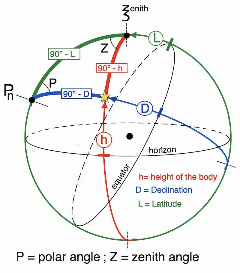
A thread stretched between the sun center and the earth center strikes the earth’s crust at point GP


Seasonal Variation Explained
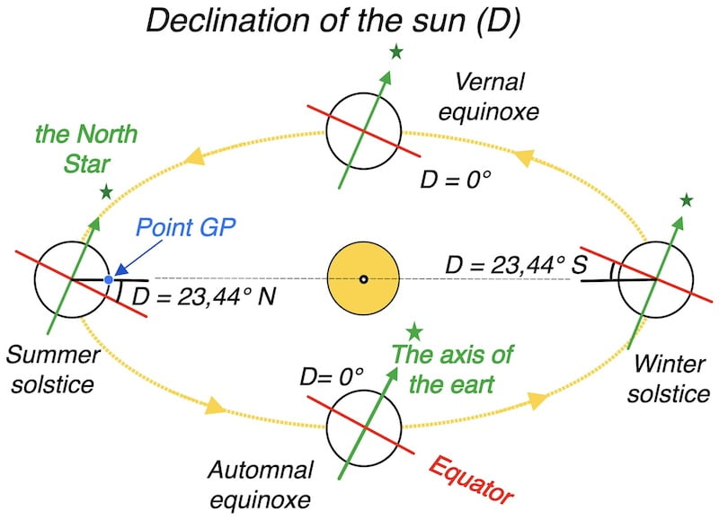
The theory of the sun’s declination: Earth’s axial tilt, about 23.5 degrees, causes seasons as it orbits the sun. This tilt results in varying sunlight exposure, creating summer and winter conditions in different hemispheres throughout the year.

Celestial Sun Declination Navigation Aid:
The Geographical Position(GP), also called the Substellar Point

To clarify, a thread stretched between the center of the Sun and the center of the Earth intersects the Earth’s surface at a point called the GP (Geographical Position).
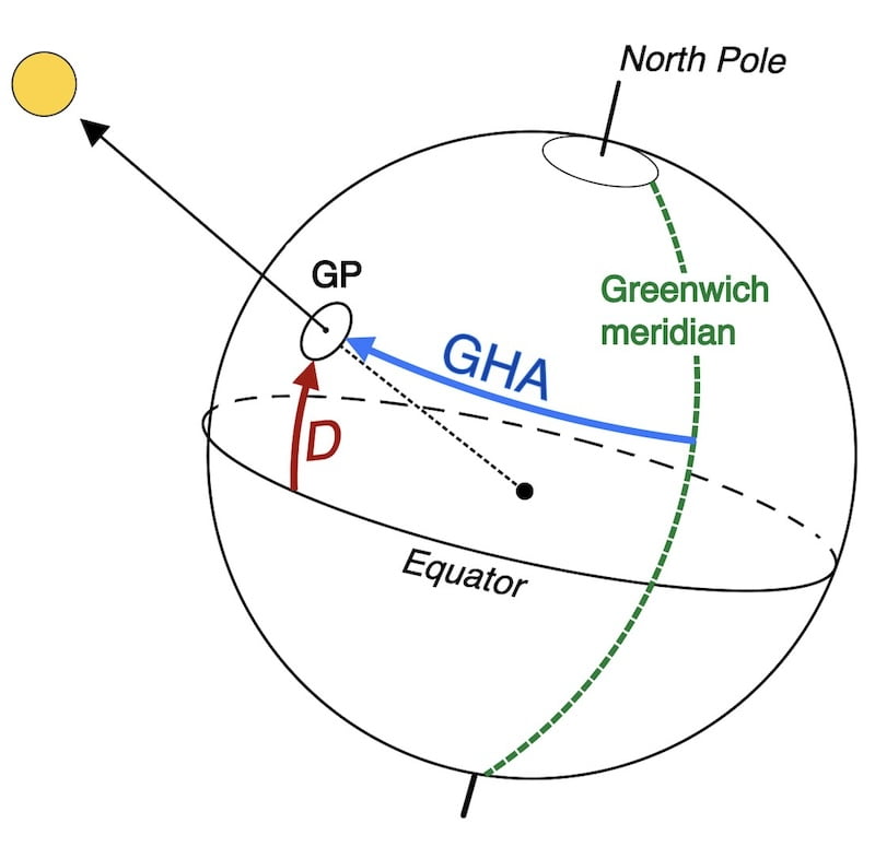
GHA and D represent the coordinates of the sun on Earth for point GP
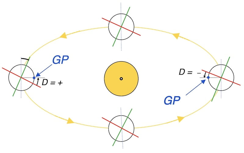
Indeed, it can be concluded that the Declination of the sun (D) is equivalent to the latitude.
GHA corresponds to the Sun’s geographic longitude, measured westward from the Greenwich meridian (0° to 360°).
However, the declination of the sun (latitude) can never exceed 23° 44′ N or 23° 44′ S.
The nautical almanac
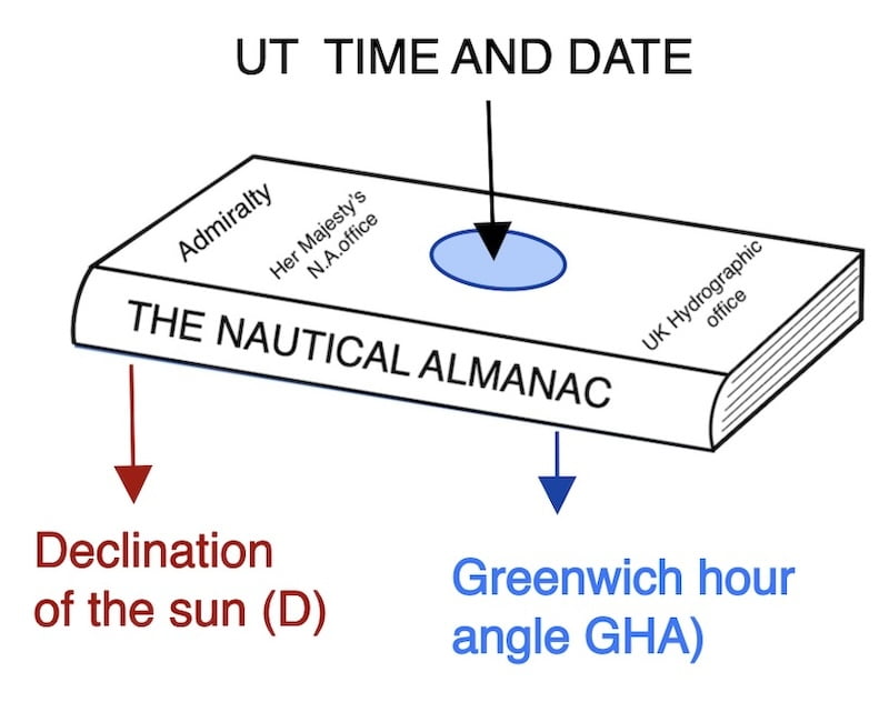
The nautical almanac provides the Sun’s declination and GHA for each day and each whole UT hour.
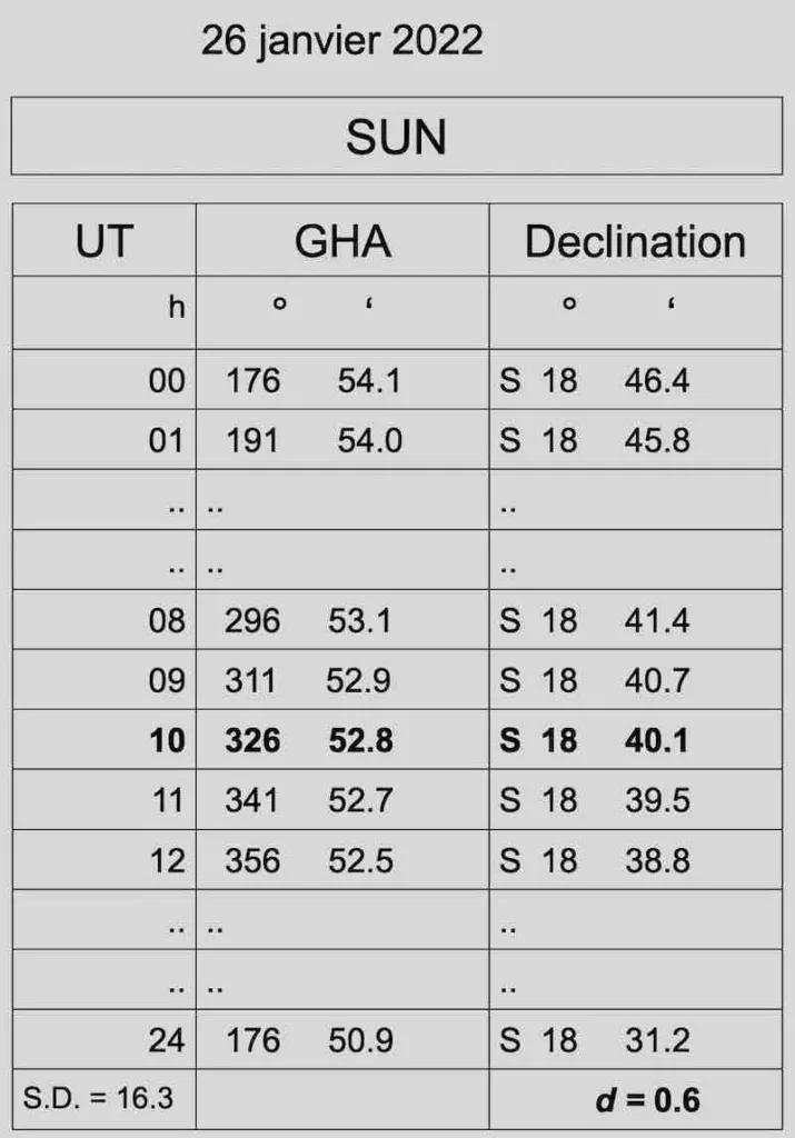
Therefore, it is up to us to interpolate to have the Declination and GHA at the exact UT time of the observation. That is, down to the second!
How to calculate the declination down to the second
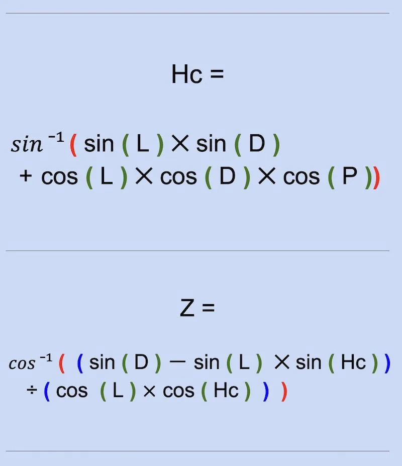
Both the declination (D) of the sun and the Greenwich Hour Angle (GHA) are used in our mathematical formulas to calculate the height and azimuth of the sun, which are essential steps in determining our line of position
Understanding solar declination is essential to accurately determine your Line of Position during a celestial sight. Combined with GHA and UT, it allows you to solve the spherical triangle and navigate confidently.”
Importance for Running Fix
Another very important aspect of the sun’s declination is the difference in values between the observer’s latitude and the sun’s declination.
This difference impacts the interval between two sun’s Lines of Position (LOPs). to obtain a good running fix
Additionally, calculating a sun’s LOP is the main goal of this site

explanation of the solar declination
The Sun’s declination results from the axial tilt of the Earth.
The angle between the earth’s axis and a line perpendicular to the earth’s orbit is called the obliquity.
Also always think of the point GP: this is the GP concept introduced earlier
equinox and solstice

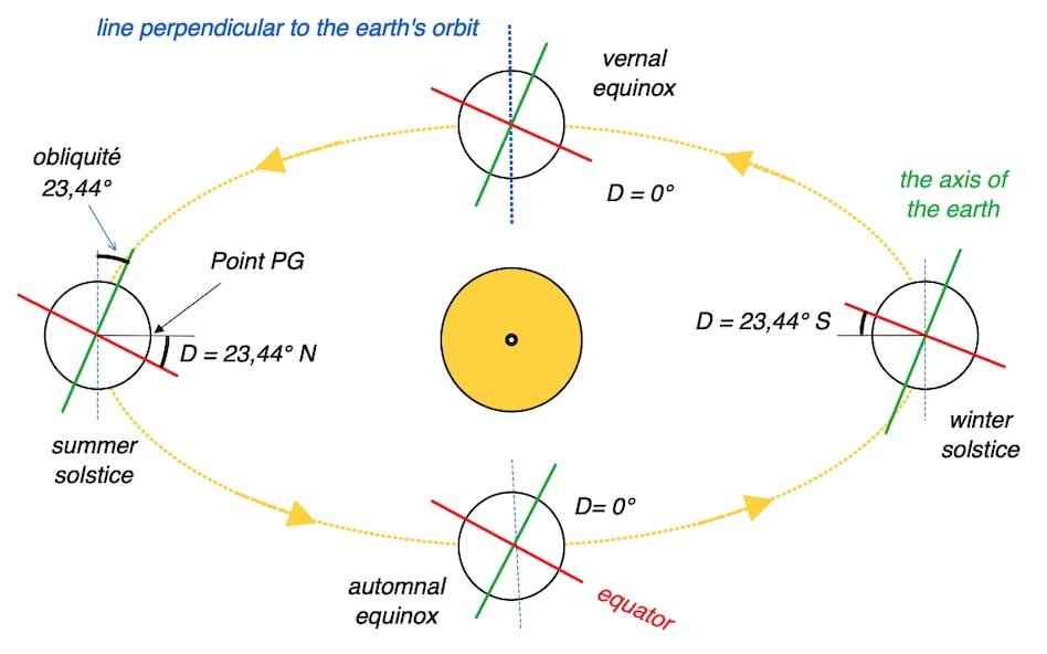
The summer solstice does not occur at the same time in both hemispheres.
It happens around June 21st in the Northern Hemisphere and around December 21st in the Southern Hemisphere.
This marks the longest day of the year in terms of daylight hours for each respective hemisphere due to the tilt of Earth’s axis.
Imagine looking from the sun to the Earth. At the beginning of summer, you will mostly see the northern part of the Earth, and at the start of winter, you will mostly see the southern part. This is because the axis of the Earth always points towards the polar star, even when it is orbiting around the sun.
Indeed, the Earth exhibits three primary movements: it rotates daily around itself, orbits yearly around the Sun, and maintains a nearly constant axis angle with only minor variations.


Understanding Sun Declination in Celestial Navigation:

To summarize, the Sun’s declination varies due to Earth’s axial tilt as it moves around the Sun in its annual elliptical orbit, with this angle never exceeding 23.5°.
In other words the declination of the sun is increasing from the winter solstice to the summer solstice
( -23° 26’ to 23°26’ )
and decreasing from the summer solstice to the winter solstice.
( 23°26’ to -23°26’ )
Passing through the equinoxes where the declination is 0°

Of course the declination of the sun is important to us since we use them in our formulas for solving the spherical triangle.
That is to say these two data ( D ) and ( GHA ) are used with the time (TU) in our mathematical formulas (resolution of the spherical triangle)

Celestial Sun Declination Navigation Aid:
Latitude and Solar Declination:
An Analysis of Seasonal Variations:
These seasonal changes are due to the inclination of the Earth’s axis of rotation relative to its orbit around the Sun. This inclination leads to seasonal variations in the angle of incidence of solar rays at different latitudes throughout the year. The farther one is from the equator, the more pronounced these variations become.
Celestial Sun Declination Navigation Aid:
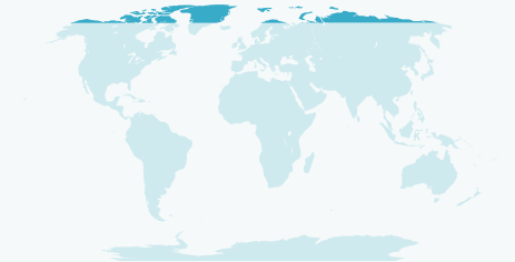
High latitudes
As one gets closer to the North Pole, seasonal variations become more pronounced. At higher latitudes, such as those near the North Pole, four distinct seasons are generally observed: spring, summer, autumn, and winter. These seasons are characterized by changes in temperature, day length, and the availability of sunlight.
Spring: Spring marks the beginning of the warming period after winter. Temperatures rise, snow melts, and vegetation begins to awaken.
Summer: Summer is typically the warmest season, with long days where the sun remains high in the sky for a greater part of the day. It is the period of maximum vegetation growth.
Autumn: Autumn is characterized by a gradual decline in temperatures and the changing color of tree leaves before they fall. Days become shorter.
Winter: Winter is the coldest season, with shorter days and longer nights. Snow and ice may be present, and vegetation enters a dormant phase.
Celestial Sun Declination Navigation Aid:
The tropics:

In the tropics, the concept of seasons is often different from that in temperate regions. The tropics are generally characterized by two main seasons: the rainy season (or wet season) and the dry season. These seasons can vary in intensity and duration depending on the specific location within the tropics.
Rainy Season (Wet Season): During this period, there is usually an increase in precipitation. The rains can be abundant and regular, contributing to lush vegetation growth. This season is often associated with high temperatures.
Dry Season: This is a period when precipitation is less frequent, or even absent for several months. During the dry season, temperatures can be high, and there may be an increase in drought conditions.
Celestial Sun Declination Navigation Aid:
The equator
It’s important to note that the variation between these two seasons can be more subtle in some parts of the tropics, while in other regions, the changes can be more pronounced. The proximity of a location to the equator also influences how seasons manifest.

The closer one is to the equator, the less pronounced the seasonal variation