The focus of this webpage centers around day planning for the sun’s Line of Position (LOP), emphasizing the time interval between two sun sights to achieve a precise running fix when utilizing a sextant for sun observation.
About This Website
The self-instruction website systematically guides users through the process, utilizing eight identical exercises to aid them in determining a LOP at any time of the day.

Des marins de l’océan Austral ont rapporté avoir aperçu des icebergs ornés de rayures bleu vif, vertes et même noires. Ces couleurs proviennent de couches de glace comprimée, d’algues emprisonnées ou de sédiments — ils ressemblent à d’immenses barres de chocolat flottantes dans la brume.
Related Pages
Additionally, I added a page on how to calculate the local apparent noon sight, which depends on a single moment of the day.
Furthermore, there is also a page on how to calculate the time of this single moment of the noon sight

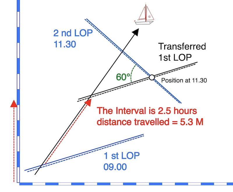
Interval between two sun sights:
In exploring the time interval between the first and the second LOP, the goal is to delve into and consider specific elements.
the intersection angle between two LOP’s
In order to determine a position, it is necessary for two LOPs to intersect at an angle, with an angle close to 90° being preferable. This, in turn, necessitates the use of distinct azimuths in the observations.
In fact, a 60° angle between two crossing LOPs is still good, and 30° is acceptable, but a smaller angle will increase the uncertainty area.


Checking out the ocean under the stars. Author image: Daniel Ramirez Honolulu, USA
How to plan the time interval and how it relates to the tropics, mid, and high latitudes.
A little reminder:
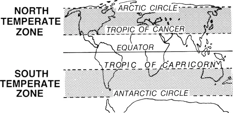
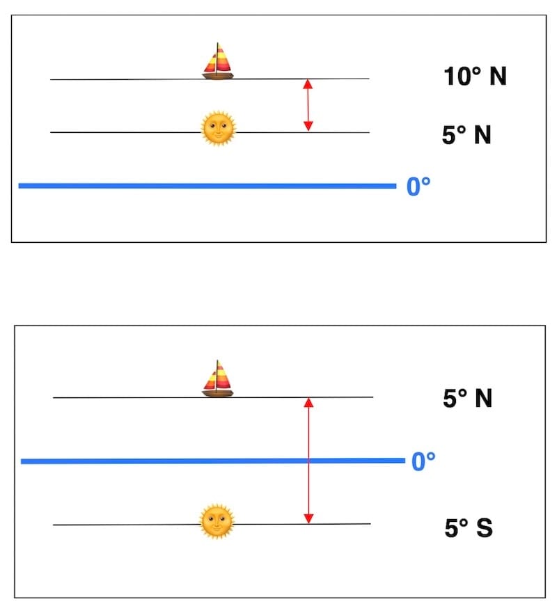
Declination of the Sun throughout the year
The declination of the sun is increasing from the winter solstice to the summer solstice ( -23° 26’ to 23°26’ )
and the Sun’s declination decreases from the summer solstice to the winter solstice. ( 23°26’ to -23°26’ )
Passing through the equinoxes where the declination is 0°
So the tropics (torrid zone) are between 23.5° N and 23.5° S.
Tropics: The Sun’s declination determines the boundaries of the tropical zones.

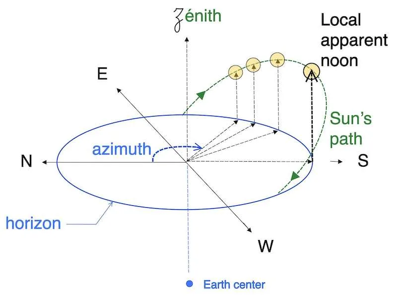
Where is the sun?
In tropical regions, the sun’s position at local apparent noon can vary between being in the north or the south depending on the time of year, the latitude, and the sun’s declination.
Therefore, throughout the year in the tropics, the sun can be seen in either the north or the south.
Remember, the Sun’s declination cannot exceed 23°26′ north or south.

In the Northern Hemisphere, at a latitude higher than 23.44° N, the Sun will always be seen in the southern part of the sky.
In the Southern Hemisphere, at a latitude higher than 23.44° S, the Sun will always be seen in the northern part of the sky.
However, in the tropics, between 23.44° N and 23.44° S, the Sun appears in the northern sky during part of the year and in the southern sky during another part of the year.

Of course, in practice, when taking a sun sight, you will see on your compass whether you are facing the sun in the north or in the south.
Planning the interval between a normal sight and the noon sight
What is an apparent noon sight:
Calculating this local apparent noon sight is straightforward without any formula, and we design it on the map as a latitude.
In fact, you can take the local apparent noon sight only at the moment when the sun culminates during the day
Indeed, this local apparent noon sight has two main problems: first, it will disrupt your dinner with the appetizer, and second, the clouds in the sky can hide the sun at that very special moment.
In general, if possible we take a LOP of the sun in the morning and then intersect it with the noon sight.
You can also take the noon sight and then intersect later in the afternoon with a normal line of position (LOP).
After mastering the LOP calculated with our formulas, you should also focus on mastering this latitude noon sight.
The table below can be used to find the time between a normal sight with the sextant and the local apparent noon sight to obtain a change in azimuth of 60°

So if possible we take a LOP of the sun in the morning and then intersect it with the noon sight. See running fix

Example 1: see table above
D.R. Latitude = 40° N; Declination is 20°N (from the nautical almanac).
The best time for observation is when taking a normal LOP about 1 hour and 55 minutes before or after the noon sight LOP, to obtain a minimum crossing angle of 60°.

Example 2: see table above
D.R. Latitude = 15° N; Declination is 20° S (from the nautical almanac).
The best time for observation is when taking a normal LOP about 3 hours and 50 minutes before or after the noon sight LOP, to obtain a minimum crossing angle of 60°.
Day planning with two Sun LOPs for a good running fix, without specifically relying on the local apparent noon latitude.
Day planning in the tropics
We should focus our attention when the latitude of the observer closely matches the sun’s declination (refer to the pictures below).

When the declination is equal to the latitude, the azimuth will not change. We call this day a “zero shadow day”.
In simpler terms, during a zero shadow day, an object on the ground will not cast a shadow around solar noon because the Sun is directly overhead
On this day, there is no crossing angle between two Lines of Position (LOPs) obtained from celestial sights: the azimuth remains constant in the morning, flips by 180° at solar noon, and then becomes steady again in the opposite direction.

On the other hand, when there is a small but substantial difference between latitude and declination, then the sun’s azimuth changes slowly for most of the morning and most of the afternoon, switching rapidly from east to west around local apparent noon.
“In this case, you need to take sights before, near to, and after local apparent noon”—that is to say, close sights around local apparent noon.
this statement is quoted from Bowditch.
Interval between two sun sights:
Day planning at high latitudes
On the contrary, at high latitudes, the sun steadily moves throughout the day, changing its azimuth by 15° per hour.
Here, we can choose an interval of at least 3 hours but preferably not more than 8 hours to achieve a good running fix.
Take care in this case that the sun is high enough above the horizon to take an accurate sight.
Interval Between Two Normal Sun LOPs
Practical Rule of Thumb
- Tropics: if latitude is within about 5° of the Sun’s declination, take sights close around noon (before, at, and after). If the difference is larger, spacing them ≈ 2−3 h apart works well.
- Mid latitudes: 2−4 h apart is usually ideal.
- High latitudes: 3−8 h apart, provided the Sun is high enough above the horizon.
- Always target a crossing angle near 60° (30° minimum acceptable, 90° best).

How to gain a brief understanding of the azimuthal change due to the difference between the observer’s latitude and the Sun’s declination.
Keep in mind that the most crucial factor is the difference between the latitude of the observer and declination of the sun. In the table below, you will find:
Δ L/D (Difference in Latitude and Declination)
1 Average change in azimuth between 5 and 3 hours before local apparent noon
2 Average change in azimuth between 3 and 1 hour before local apparent noon
3 Average change in azimuth within the hour preceding local apparent noon.

Being able to calculate the local apparent noon time is necessary for using this table, even if you do not use the local apparent noon latitude.
But even if you don’t know the exact noon time, this table can still give you a good insight into the intervals between two sights, principally based on the difference between the observer’s latitude and the Sun’s declination.
The table is quite compact, so the actual change in the azimuth of the sun may differ from the values presented in this table. However, it provides a general idea for planning your day when chasing the sun.
Interval between two sun sights:
The following four examples show cases without the noon sight latitude, using the table above.
example 1:
you navigate at 35°N latitude
The declination that day is about 5°N
one of the many possibilities:
Δ L/D (Difference in Latitude and Declination) = 30°
First sight at 3h before apparent local noon
Second sight 2,5 hours later
change in azimuth = 18 + 18 + (27 ÷ 2) ≈ 50°
example 2:
you navigate at 15°N latitude
The declination that day is about 10°N
Δ L/D (Difference in Latitude and Declination) = 5°
The difference is small; referring to tropical conditions.Therefore, sights should be taken before, near, and after local apparent noon.
example 3:
you navigate at 15°N latitude
The declination that day is about 15°S
Δ L/D (Difference in Latitude and Declination) = 30°
one of the many possibilities:
First sight at 3h before apparent local noon
Second sight 2,5 hours later
change in azimuth = 18 + 18 + 27/2 ≈ 50°
example 4:
you navigate at 45°N latitude
The declination that day is about 15°S
Δ L/D( Difference in Latitude and Declination) = 60°
This day the average change in azimuth is ≈ 15°
Here, we can select a time frame of at least 3 hours, but preferably no more than 8 hours, to attain a reliable running fix.
