

Local Apparent Noon Time at Sea — Theoretical Explanation and 4 examples
First, let’s review the theory of the noon sight.
On this page, you’ll learn a simple and reliable way to determine local noon time—accurate to within a few minutes, perfectly acceptable for our purpose, except for high-speed vessels on east–west routes.
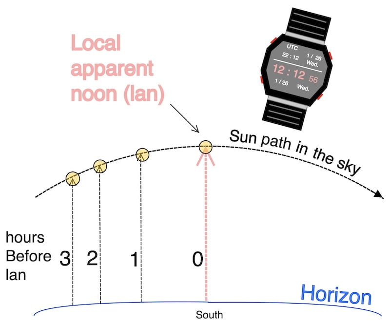
Indeed, it is enough to go on deck about ten minutes beforehand to compensate for those small inaccuracies and begin taking observations of the Sun at short intervals until it reaches its highest point and starts to descend.
At that moment, simply note the altitude at the culmination point as well as the time of local noon; there is no need for the time to be accurate to the exact minute.
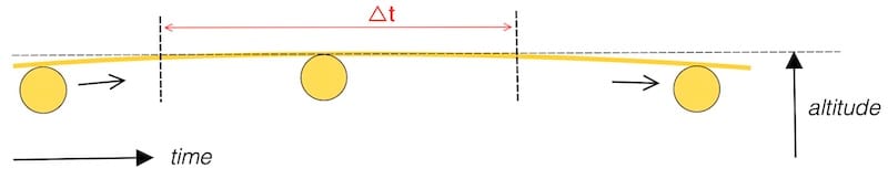
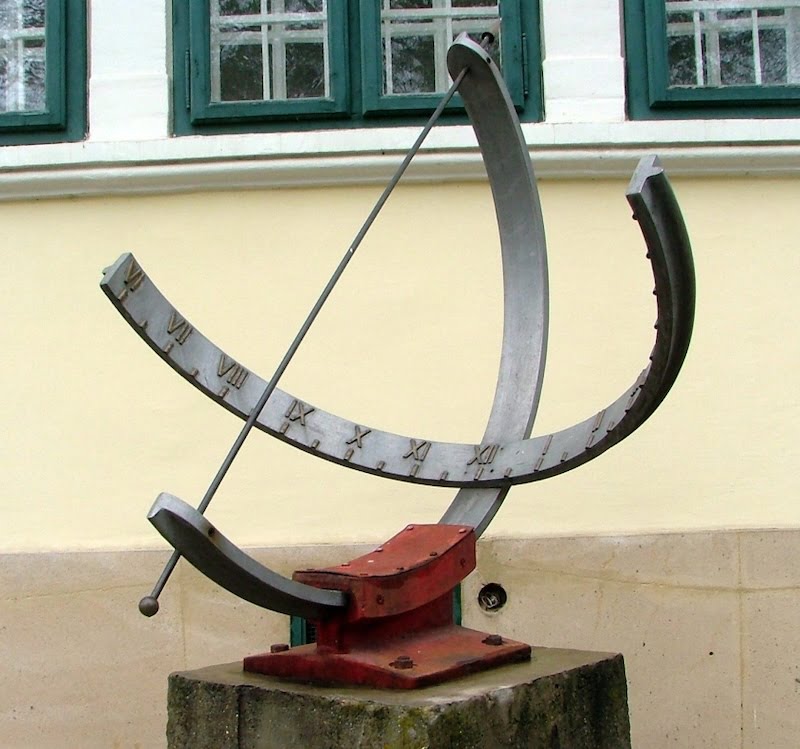
The figure shows that measuring the maximum altitude is not difficult, but that determining the exact instant of culmination is impossible within the Δt interval: the change in altitude is too small to allow reliable time determination.
To obtain a more precise local apparent noon time (LAN) , it is necessary to take the ship’s own movement into account. This can be important for fast ships that are heading more towards the east or west, but it complicates the calculation due to the formulas that need to be remembered.(see appendix below.)
Local Apparent Noon Time at sea: explanation:
The apparent solar time varies due to the Earth’s elliptical orbit and axial tilt, causing the Sun’s apparent motion to speed up or slow down relative to the mean solar time.
Mean Solar Time: This is the average solar time over the year, assuming a uniform 24-hour day. (“Clock time” is our average, consistent time).

Equation of Time: The Equation of Time graph typically shows the difference (in minutes) between apparent solar time, as measured by a sundial, and mean solar time, as indicated by a watch, throughout the year. This difference oscillates, reaching up to about ±16 minutes.

This classic equation of time theory is good to know for a mariner, but we don’t have sundials on board. Additionally, observers at different longitudes experience different apparent noons.
Therefore, we need to apply an additional longitude correction to obtain the local apparent noon time.
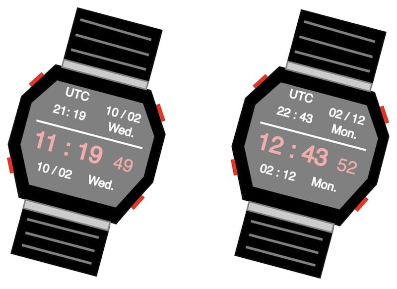
Moreover, while navigating within the same time zone over the course of a year, apparent noon can occur as early as 11 h 19 or as late as 12 h 43, depending on the time of year and the difference in longitude. This variation doesn’t even take daylight saving time into account.
Conclusion
As you can see, the difference in the noon sight can be almost one and a half hours within a single time zone. For this reason, you should never simply wait until “12 h 00” to take a noon sight. It is best to rely on the method using the Nautical Almanac daily page, as described below.

In 1992, a container ship lost several containers in the North Pacific. One burst open, releasing 28,000 rubber ducks and bath toys. They drifted across oceans for decades, helping oceanographers map currents. Even today, “friendly floatees” are still washing up on distant beaches.
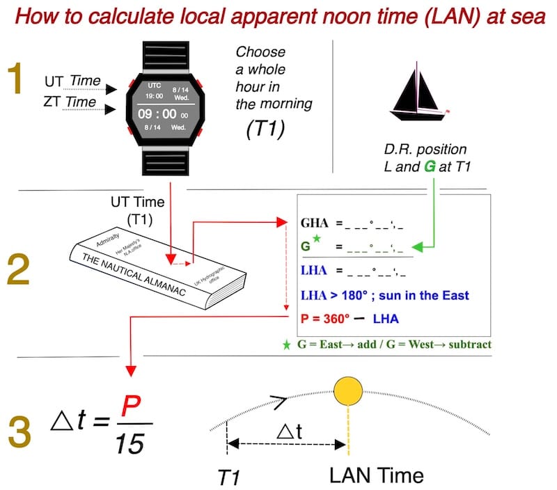
Local Apparent Noon Time at sea:
There are several ways to calculate the local noon time; here we’ll use the method based on the polar angle (P).
To calculate the noon time using this method, you need to know how to determine the polar angle (P) beforehand!

Remember, the main purpose of this website is to determine the Sun’s Line of Position (LOP) at any time of the day using the Marcq St. Hilaire method, with the ‘La Rochelle’ exercise.
It is essential to understand that the local apparent noon sight technique as explained on this page can only be applied at a specific time of the day
Also, with the apparent noon time, the observer’s latitude, and the declination of the Sun, you can plan the appropriate intervals between two or more sun sights for that day.

Initiating the local apparent noon (LAN) time , without the vessel’s own movement
We begin the ocean passage with the daily pages downloaded from the Nautical Almanac.
We also have a reliable watch set to UT!

let’s see how it works:
Early in the morning, for example after breakfast, we take the UT time of the next whole hour (T1) and the estimated longitude.
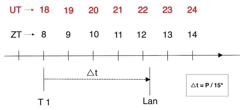
With no vessel movement, keep the DR position fixed. Choose any convenient whole-hour UTC time for T1, prior to LAN.
Example 1 (without the vessel’s own movement)
Day 06 mars 2022
L = 33° 21’ N; G = 150° 18’W (dead reckoning at T 1)
T1 = UT time whole hour = 18h 00
We can calculate the zone time (ZT), or the local time on board, from the chosen UT.
Longitude = 150° 18′ West (between 142.5° and 157.5°)
ZD = +10
ZT = UT – ZD = 18 h 00 – (+10) = 08 h 00
18 h 00 UT, corresponding to 08 h 00 zone time( ZT) on board. See explanation time zone table
Zone time (ZT) often called local time (LT)
It’s better to use a whole hour (T1) so that we don’t have to calculate the increment from the minutes and seconds.
Remember to calculate the noon time, you need to know how to determine the polar angle (P) in advance!

With this UT time (T1), we will look for the GHA in the nautical almanac and calculate P (polar angle)

P is calculated at the chosen T1 (18:00 UT).
P will decrease to zero at a rate of 15° per hour, reaching zero at local apparent noon time.

△t = P/15°
LAN Time = T1 + △t
LAN Time:
18 h 00 + 04 h 12 = 22 h 12 UT
08 h 00 + 04 h 12 = 12 h 12 ZT
Simplified approach to calculating apparent noon latitude
How to choose the time T₁
1. Vessel stationary or nearly so
2. Vessel underway
3. Vessel underway: exact method (see appendix)
1. Vessel stationary or nearly so
For vessels that are stationary or almost stationary, the choice of T₁ matters little, since the estimated longitude G does not change—or changes very little.
(See Example 1 above: one could just as well have chosen 19:00, 20:00, or 21:00 UT.)
2. Vessel underway
For vessels in motion, it is preferable to choose a time T₁ and an estimated longitude close to the Sun’s apparent noon time. By doing so, the vessel’s movement during the short period between LAN and T₁ is not taken into account, but this will not induce a significant error except for high-speed craft.
You simply need to be on deck about ten minutes before the calculated meridian time, in order to compensate for small uncertainties in the dead reckoning and to observe the Sun’s ascent until it reaches its highest point.
This is a typical cruising navigation method, also used in professional practice and recommended for its simplicity.
Summary: Choose the time T₁ — preferably a whole hour — shortly before local apparent noon, along with the estimated longitude.
Calculate P, divide P by 15, and thus obtain the time interval △t between T₁ and local apparent noon.

Note: The difference between the exact meridian time and the one calculated with an estimated position affected by the usual navigation errors remains relatively small, since the vessel’s movement—even at 8 to 10 knots—is negligible compared with the Sun’s apparent motion, which covers 15° of longitude per hour.
3. Vessel underway: exact method (see appendix)
In the case of the exact method described in the appendix, the choice of T₁ is of little importance, since the additional correction accounts for the vessel’s movement.
This section is mainly intended for cadets and navigators who wish to study the method in greater depth, rather than for ordinary cruising practice.
Astronomical Navigation: Calculating Local Noon time
Example 2 (vessel underway)
Choose a time T₁ and an estimated longitude close to the Sun’s apparent noon.
Indeed, you are sailing off the coast of the Guadeloupe Islands on a beautiful, almost cloudless day. Your estimated position (D.R.) is 15° 54.4′ N, 056° 34′ W at 11h 00 zone time on board on June 6, 2022.
we’ll take this as T1 since it appears close to LAN
1.Calculate UT Time of T1
2.Calculate the local noon time.
3.Should I face the Sun in the north or south direction at that time?
1.
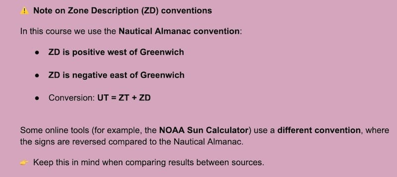
056° 34′ W → ZD = +4 (see time zone table)
UT = ZT + ZD
UT = 11 h 00 + ( +4) = 15 h 00
2.
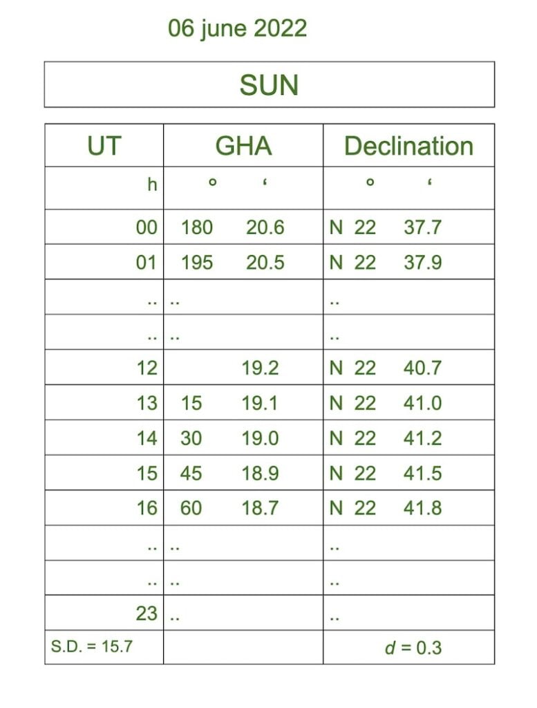
GHA = 45° 18.9′ at 15h 00 (T1)
G = 56° 34.0′ West
________________ ⎼
LHA = 348° 44.9′ ⇒ P = 11° 15.1′
The value of P diminishes at 15° per hour and is zero at the moment of local apparent noon.
△t = P/15°
△t = 11° 15.1′ ÷ 15° = 0h 45m
LAN Time = T1 + △t
LAN Time:
15 h 00 + 0 h 45 = 15 h 45 UT
11 h 00 + 0 h 45 = 11 h 45 ZT
Is the Sun to the north or to the south?
Latitude = 15°54.4′ N; Declination = 22°41′ N
D > L northern hemisphere
We are facing the Sun in the northern direction.

EXERCISE 1 (vessel underway)
Now do it yourself.
The answers to this exercise are at the end of the page.
Sailing off the coast of West Africa on a westerly course at 8 knots. you enjoy calm seas and an almost cloudless sky.Your dead-reckoning position is 31° 25′ S ; 019° 05.6′ W at 11h 00 zone time (local time) on January 26, 2022.
We will take this time for T1, because it seems close to LAN time

- Calculate UT time of T1.
- Calculate the local noon time.
- At that time, should you face north or south to see the Sun?
In conclusion
Typically, during a noonsight, the observer measures the altitude of the Sun when it is at its highest point in the sky (culmination). The altitude of the Sun at this moment is directly related to the observer’s latitude.
By focusing on accurately measuring the Sun’s altitude at its highest point, you eliminate the necessity for precise timekeeping during the observation, thereby saving time and simplifying the process.
In other words, you do not need to record the time at that very moment; it’s just you, the Sun, the sextant, and perhaps some very nasty clouds.

APPENDIX
Influences of Vessel Motion on LAN determination:
exact method:
Some navigators prefer to account for the vessel’s movement with a more precise method, particularly for high-speed craft sailing on east–west routes.
This section is intended mainly for navigation students, rather than for the everyday cruising sailor.
Knowing your calculated noon time within about 10 minutes is perfect, as it allows you to wait calmly for the Sun’s highest point and begin observing about 10 minutes beforehand.
As a matter of fact, this movement affects the time interval between T1 and local apparent noon.

Local Apparent Noon Time at sea:
The exact method of how to calculate the local apparent noon:
Here we also present the exact method for calculating the local apparent noon.
The uncertainty of the vessel’s speed and course can still affect the accuracy of this method.
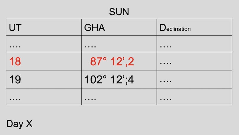
Example 3: Vessel underway and exact method.
6 mars 2022
estimated position at 18 h 00 UT:
L = 33° 21’ N;
G = 150 °18’W
SOG (speed over ground) = 12 knots.
COG (course over ground) = 300°
Additionally, T1 is the UT time at the whole hour, which in our case is 18 h 00, corresponding to 08 h 00 local time, which is early in the morning on board of our vessel.
Remember, with this exact method, you may choose any time as T₁ before apparent noon; the final result will be the same.
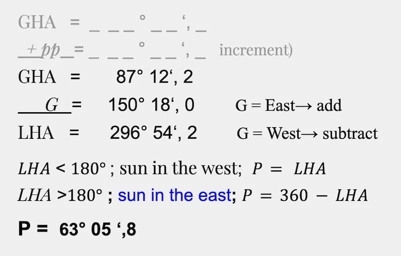
GHA = 87° 12’,2 at 18h 00 UT
We have previously established that the accuracy of determining Local Apparent Noon (lan) is hindered by the impact of a vessel’s motion, particularly when navigating on a course close to east or west.
In fact, this movement alters the time interval between T1 and Local Apparent Noon.
Instead of using the sun’s rate of 15°, we adopt a relative rate that incorporates the vessel’s motion, as indicated by the formula below.
The formulas :

Calculation with relative rate:
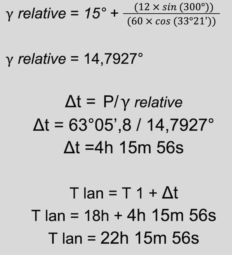
T lan = 12h 15m 56s local time
Finally, the difference between the method that takes into account the vessel’s own movement and the one that does not is about 4 minutes.
But if you are prepared 10 minutes before noon with your sextant outside and start following the sun’s ascent until its culmination, you will be able to find your latitude safely.

Answers exercise 1
1. UT = ZT + ZD ⇒ ZD = +1
UT = 11 h 00 + 1 = 12 h 00
2. Local noon time:
GHA = 356° 52.5′ at 12h 00 UT (T1)
G = 19° 05.6′ West
________________ ⎼
LHA = 337° 46.9′ ⇒ P = 22° 13.1′
△t = P/15°
△t = 22 13.1′ ÷ 15° ≈ 1h 29
LAN Time:
12 h 00 + 1 h 29 = 13h 29 UT
11 h 00 + 1 h 29 = 12h 29 ZT
3.Sun in the North