

Azimuth Tables for Celestial Navigation: Introduction to Azimuth Tables
Instead of calculating the azimuth, you may use the azimuth tables.
Background and Purpose
The tables of Louis Bataille were widely used in France for the teaching and practice of classical celestial navigation. In my own work, their use is limited to the determination of azimuth, based on only about ten pages arranged in two separate tables.
The second table is particularly elegant in its design, as it combines four different arguments. I have recomputed its values and streamlined it for a single purpose: the direct determination of azimuth.
Use in Practice
These tables integrate naturally into a practical navigation routine: using data from the nautical almanac (declination and hour angle), together with an assumed position, they provide the azimuth needed to draw the line of position.
Reminder: Easysextant provides Nautical Almanac pages (2026–2040) on this website.
In today’s navigation environment, largely dominated by electronic systems, their use still retains real value. Their simplicity is appealing, and they remain firmly rooted in the tradition of classical navigation, still appreciated by experienced mariners.
Use in Practice
Louis Bataille lived mainly during the late 19th and early 20th centuries. Although his name is now rarely mentioned outside specialized circles in the history of astronomy or navigation, he belongs to the tradition of French scholars who contributed to the reliability of nautical calculations. His work reflects the transition between classical navigation and modern methods of position fixing at sea.
What You Will Find on This Page
On this page, you will find an explanation and an example of how to use these tables.
After finishing the example, you can find 8 other fully worked-out examples for download here.
The primary focus of our website is to offer guidance on the precise calculation of the Line of Position (LOP).

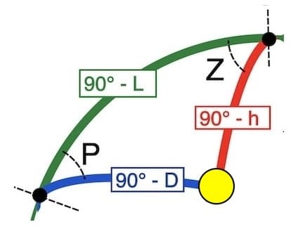
Azimuth (Zv) or True Azimuth
Azimuth is a mathematical concept used in navigation and surveying to describe the direction of a point relative to a reference direction, typically north.

It is usually measured in degrees, clockwise from north, and ranges from 0° to 360°.
Introduction azimuth tables

Learning by Example
The simplest way to explain azimuth tables is by example.
In fact, you may find that you become more proficient with the tables than with using a scientific calculator to obtain Zv.

First part of the worksheet “La Rochelle”
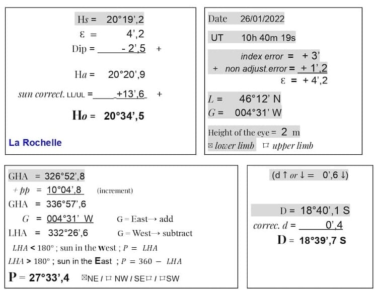
L = 46° 12′ N (rounded 46° N)
D = 18° 39.7′ S (rounded 19° S)
LHA = 332° 26.6′
P = 27° 33.4′ (rounded 27.5)
Note: The values have been rounded, as an accuracy of about 1° in azimuth is generally sufficient for plotting the Line of Position in practical navigation.
Table 5 (L.Bataille): table 1 and table 2
Page 46: m = −0.64
(negative because P is less than 90°)
Page 51: n = −0.24
(negative because L and D are of different names (N/S)
m + n = −0.88 ⇒ ∣ m + n ∣ = 0.88
Returning to Table 2: in step 2, the central values were denoted by n, whereas in step 3 they are used as m + n.
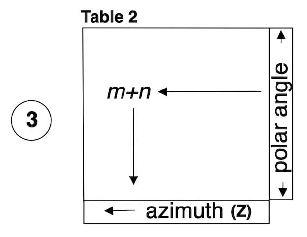
Using the polar angle P, find the page where the value of m + n corresponds, then move downward to read Z.
here page 54 and Z = 27.5°
⚓ Note: For these tables
Z = intermediate azimuth (0°⎼90°).
Zv = True azimuth (0°⎼360°).
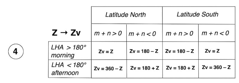
LHA > 180° (morning)
Latitude North
m + n < 0
Zv = 180° – Z
Zv = 180° − 27.5° = 152.5°
After completing and understanding the use of the L. Bataille table, you can test your skills with the 8 training exercises and their solutions.
Technical Appendix — L. Bataille Tables
Cotangent formulas
cot Z . sin P = − cos P . sin L ± tan D . cos L
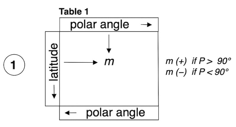
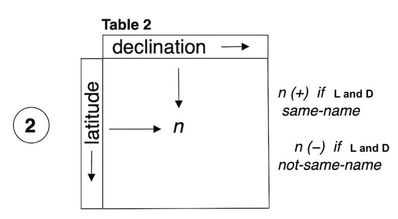
The values m, n and (m+n) in the tables are always positive.
Table 1 → − cos P . sin L = m
m (+) if P > 90°
m (−) if P < 90°
Table 2 → tan D . cos L = n
n (+) if L and D
same name
and n (−) if L and D
not same name
Determination of the azimuth
Table 2 → cot Z . sin P = m + n
Using Table 2 again, with P and (m+n), the azimuth Z is obtained.
The value of Z lies between 0° and 90° (quadrantal angle).
The true azimuth Zv is then determined.
The Ingenuity of the Bataille Tables
L. Bataille achieves a true masterstroke by designing a method in which the same central values of Table 2 are reused successively. After the two entries in Table 1 (P and L) used to obtain , then the two entries in Table 2 (D and L) giving , this same Table 2 is immediately reused with P and to obtain the azimuth Z directly.